Urban Futures Hackathon: Design + Data Scenarios for NYC
By Anton Rozhkov and Marcella Del Signore
The Urban Futures Hackathon is a joint initiative between the New York Institute of Technology School of Architecture & Design (M.S. Urban Design) and New York University Tandon Center for Urban Science and Progress (M.S. Urban Data Science) that bridges spatial design and urban informatics through rapid, place-based scenario building for New York City.
Over an intensive two-day format, interdisciplinary teams of students in design, urban science, data analysis, and policy co-created data-informed proposals that connect design inquiry with evidence-based analysis and practical policy implications. The project’s objective is to cultivate actionable ideas for how cities can evolve toward greater equity, resilience, and collective well-being when design methods and data science are integrated from the start.
Mixed teams (together with mentors from both institutions and outside) worked through four thematic lenses: Public Space & Behavior, Spatial Justice, Equitable Mobility, and Resiliency. Methodologically, each team combined spatial analysis (e.g., mapping access, risk, and disparities), targeted data visualization, and scenario prototyping (concept boards, maps, and interactive artifacts) to move from diagnosis to intervention.
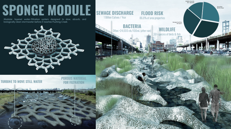
Nine teams focused on distinct NYC case areas: Broadway Junction/East New York, Brooklyn Navy Yard, East Side Coastal Resiliency, Gowanus Canal Waterfront, Harlem River Greenway, South Brooklyn Marine Terminal, Willets Point, and Hunts Point Peninsula.
Early outcomes include curated scenario boards, maps, and data visualizations that translate complex urban systems into legible, decision-relevant narratives. The project ends with a public exhibition in March 2026, reviewed by a jury spanning public agencies and academia, positioning the hackathon as both a pedagogical innovation and a platform for civic dialogue.
By demonstrating a workflow that tightly couples design and data, the initiative advances emerging practices in planning, urban design, and policy, as well as in technology and ethics.