National Gentrification Intensity Map
By John Lauermann, Alice Viggiani, and Emely Perkins
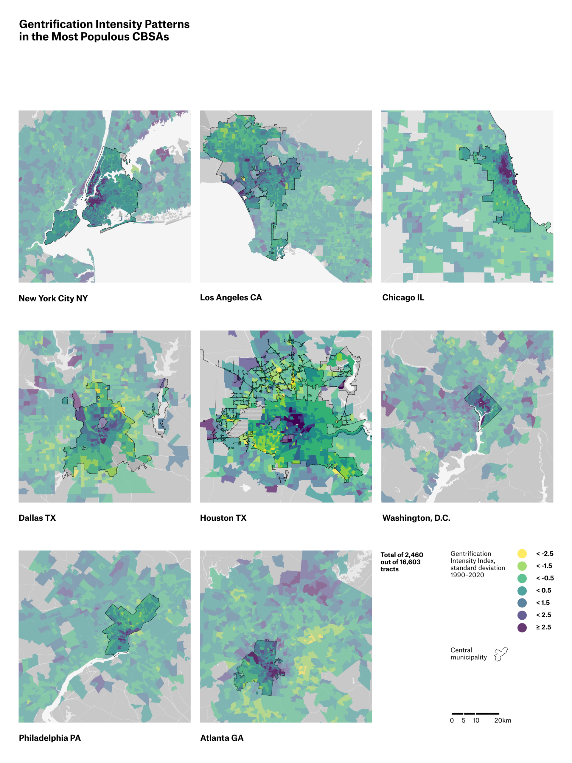
There is extensive debate over how gentrification impacts U.S. cities. Research on the topic, however, is often concentrated on case studies in large global cities. Even within large cities, most studies focus on either individual neighborhoods or central municipalities, geographies that may not effectively capture underlying spatial patterns. This study asks if gentrification occurred in the broader geography of U.S. communities, and how the national gentrification frontier evolved from 1970 to 2020. We use open data resources, open source tools, and exploratory data analysis methods to build a national, longitudinal map of gentrification indicators across approximately 56,000 census tracts in over 800 metropolitan regions. The national map reveals novel patterns including gentrification in smaller cities, suburban gentrification, and expansion of the gentrification frontier into a more demographically diverse geography that increasingly includes majority-minority neighborhoods. These patterns suggest that gentrification should be interpreted within the broader, evolving geography of affluent neighborhoods, which have always extended beyond large global cities and often involve both the urban core and the suburbs. Our contribution is a data product and methodology for mapping gentrification patterns across a diverse geography of community types. The map draws on open data products that are available across all U.S. communities, not only in major cities. This allows for comparison, supports reproducibility, and extends analysis into historically under-researched places with lower levels of data availability.
Related work:
Lauermann, J., Viggiani, A., Wu, Y., & Smash, N.* (2026). National Gentrification Intensity Map: Mapping Gentrification Across US Communities, 1970 to 2020. The Professional Geographer, doi:10.1080/00330124.2026.2625975
Lauermann, J., Wu, Y., Feldman, A., Viggiani, A., Wang, Z., & Smash, N.* (2026). National Gentrification Intensity Map [dataset]. Harvard Dataverse. doi:10.7910/DVN/DPKO3I
Lauermann, J., Alexander, Z., & Wang, Z.* (2025). Mapping super-gentrification in large US cities, 1990–2020. Urban Geography, doi:10.1080/02723638.2025.2528418
- * = Pratt student coauthor
-
 I am an Associate Professor in the School of Information. My teaching practice includes a rotation of graduate-level courses in GIS and data science. I also serve as curriculum and…